When we wake up the next morning we decide to try the employment center and try a few phone calls. Obviously the employment center is not the right place to go, it's for people looking for a "real" job. We try to call but the public phone we choose doesn't work so finally we decide to leave Vernon. When we get to Oyama we go to every orchard we see and ask if they need us. We get a lot of contradictory information and there doesn't seem to be much job around here although we see apple trees full everywhere. As for a remarkable person we meet in our quest; a guy who just hired mexicans so he won't hire french candians because he has to pay them a fare wage! WOW!
Finally we end with an offer for grape picking in Kelowna for 1 day. But everyone seems to be mentioning some Roger guy in the village that might need help. So we decide to go back there, finally see people picking apple that tell us to stay. After a few phone calls and the worst conversation I had on the phone in years, I couldn't understand anything the other person was saying we get a job for the next morning.
He comes to pick us up and brings us to a "camp" where four french people are already staying. Good news is we will have a camper, and it's really clean and much more comfortable than our tent.
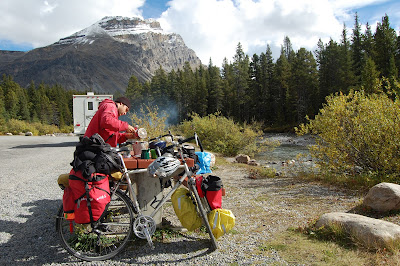
Tomorrow, 6h45 we are gonna start picking for Paramji, an Indian guy who is renting orchards in the area. Distance: 25 km
vendredi 24 septembre 2010
jeudi 23 septembre 2010
23/09/10 Sicamous to Vernon
Biking in the valley remembers me of the great lakes shores with all those orchards, corn field and cows. We are now on a mission, finding an orchard where we can pick apples for a couple of days. In Vernon, we stop at the information center but they have no clue how to help us. They give us the address of an employment center. We will try that tomorrow morning. For the moment, we go the the grocery store and later, we find a nice wood behind the Wal-Mart where we pitch the tent. Distance: 75 km
mercredi 22 septembre 2010
22/09/10 Three Valley Lake to Sicamous
Wow! Finally a sunny day. The Okanagan valley is getting closer . We hit Sicamous late in the afternoon. We cook dinner on the shore of the lake. There are hundreds of big fishes jumping off the water in front of us. Xavier thinks of the first explorers who made the trip across the rockies and could finally enjoy the warmer weather and huge fishes after so many days of starvation. Actually he also thinks he has been starving for days in the rockies, not really starving but living off Sidekicks and lentils mixes, and he's trying to compare himself to those explorers to feel better! Distance: 65 km
mardi 21 septembre 2010
21/09/10 Glacier to Three Valley Lake
This morning, we realize that my back wheel bearings are worn out. Actually it has been making a strange noise for 3 days but I was trying to ignore it. We will have to find a bike shop in Revelstoke. The weather is really weird out there. Until noon, it is both rainy and sunny at the same time. Bizarre. In Revelstoke, we find a bike shop who does a good job on my wheel for only 18$. While we are waiting for the repair, we cook hamburgers on the plaza. We pitch the tent behind a huge pill of rocks used to block avalanches in the winter.
Distance: 65 km
Distance: 65 km
lundi 20 septembre 2010
20/09/10 Golden to Glacier National Park
Yes, the weather is still pretty ugly outside but we have to move. Anyway, it is supposed to be sunny tomorrow so our stuff will dry out. We climb the Glacier National Park and just when we get to the start of Rogers Pass rain starts to pour down. Rogers Pass is suppose to be the worst stretch of the highway 1. Now maybe it's because we are too busy complaining about the weather but Rogers Pass really isn't that bad.We are kind of dissapointed. We were expecting a very hard climb but there was nothing extraordinary, except for the several tunnels that go trough the mountain. At the top and it is freezing. We take refuge in the hotel there and prepare a cesar salad. A hot chocolate would be better but they don't have anything warm for sell. We decide to go down and hope the weather will get better. We finally pitch our tent under a bush of fir, where it's kind of warmer, at the exit of the park and eat the dinner under the rain. Is the sun gone for ever? Distance: 108 km


dimanche 19 septembre 2010
19/09/10 Golden
When we wake up around 8h30, rain is pouring outside. We watch the weather forecast on TV and it is going to get worst later. We decide to stay at the motel, relax, sleep and eat like pigs, Xavier especially, to make up for the hard days we had in the rockies.
samedi 18 septembre 2010
18/09/10 Yoho to Golden
This morning, the hostel is at full capacity. The last persons arrived around midnight. All our stuff from the day we arrived is still wet because the heating is turn off during the day to save gas. Anyway, we have to go back on our bikes. The road to Golden is amazing, all downhill. The road has been construct between huge cliffs and a river. The shoulder is very small, the highway is in construction and trucks are going fast.We arrive in Golden under the rain and decide to take a motel and cook a huge dinner. For 60$ we particularly appreciate the hot tube and the sauna, and the warm bed obviously.
Distance: 60 km


Distance: 60 km


vendredi 17 septembre 2010
17/09/10 Yoho
Aujourd'hui on a fait une superbe randonnée avec Anna et Roni.


Iceline via Little Yoho: 20.8 km, 695 m d'élévation
jeudi 16 septembre 2010
16/09/10 Lake Louise to Whiskey Jack Hostel (Yoho)
J'ai est vraiment assez du froid et de la pluie. J'ai jamais froid normalement et là, ça fait une semaine que je me les gèle. Je veux m'en aller. Amélie insiste tout de même pour passer par le lac avant de descendre vers Yoho. On s'arrête à la boulangerie du village et on achète une cargaison de pains tirés de l'étagère " Day-Old-Bargain", la seule denrée à un prix raisonnable de tout le village.
 De nouveau sur la route, on passe encore au carwash hivernal. Cette fois, mère nature y met toute la sauce comme pour nous dire de ne plus jamais revenir à Lake Louise en vélo. La route est en pente descendante alors ça dure pas trop longtemps sauf que vu qu'on ne pédale pas, on gèle. Nous sommes tous les deux en état d'hypothermie. Welcome in BC!
 Le remède à tout cela c'est la montée de Yoho vers le Whiskey Jack Hostel. Ça monte comme c'est pas possible. À un certain moment, on doit même descendre et pousser sur nos vélos. N'en reste pas moins que nos pieds trempent dans de l'eau glacée. Un peu en avant d'Amélie, je tourne un coin et me retrouve face à face avec un wapiti. L'animal est pourchassé par deux touristes en voiture. Il est pris sur la route entre eux et moi. J'ai l'impression qu'il va me charger. Heureusement, il opte plutôt pour le bois sur le côté de la route. Merde, c'est gros un wapiti!
On arrive à l'auberge trempé et dégouté de tout. Le Whiskey Jack Hostel est un auberge jeunesse juché tout en haut du parc national de la Yoho, juste au pied du glacier. Sans électricité, la cabane est éclairée et chauffée au gaz. La douche chaude est plus que bienvenue. En plus, on trouve quantité de nourriture abandonnée par d'anciens voyageurs. On se sert. On trouve même une belle bouteille de Ricard presque pleine. Le soir, on rencontre deux groupes d'Allemands, donc Anna et Rony. Bien sympathique comme endroit. Distance: 45 km


On arrive à l'auberge trempé et dégouté de tout. Le Whiskey Jack Hostel est un auberge jeunesse juché tout en haut du parc national de la Yoho, juste au pied du glacier. Sans électricité, la cabane est éclairée et chauffée au gaz. La douche chaude est plus que bienvenue. En plus, on trouve quantité de nourriture abandonnée par d'anciens voyageurs. On se sert. On trouve même une belle bouteille de Ricard presque pleine. Le soir, on rencontre deux groupes d'Allemands, donc Anna et Rony. Bien sympathique comme endroit. Distance: 45 km

mercredi 15 septembre 2010
15/09/10 Rempart Creek to Lake Louise
Hier soir en rentrant, on a rencontré Tom, un hitchhiker allemand qui s'en allait à Edmonton. On a passé la soirée à parler autour du poêle à bois. On commence vraiment à manquer de nourriture, surtout qu'il faut se reclaquer le sommet de Bow avant de redescendre à Lake Louise. On fait un échange. Tom nous donne un pain et nous on lui donne une lampe de poche reçue en cadeau à Winnipeg. Tout le monde est heureux.
 On se met en route vers midi. À Saskatchewan Crossing, on recroisse les Australiens. Ils ont l'air encore plus frigorifiés qu'hier. Ils discutent avec un Allemand géant. Il doit faire au moins sept pieds de haut et possède une barbe plutôt imposante. Le gars à pris un avion pour Montréal ou il a acheté un vélo rose au premier Canadian Tire sur son chemin. Il a ensuite pédalé jusqu'à Jasper et est maintenant sur le chemin du retour pour reprendre un vol pour l'Allemagne depuis Montréal. Le vélo est deux fois trop petit pour lui et la moitié des vitesses ne fonctionnent plus. Il a accroché son sac à dos à l'arrière. Nous qui pensions être intenses avec nos vélos usagés...
De nouveau sur la route, on en arrache sous la pluie, à pousser sur nos pédales pour monter les côtes. Un peu avant la montée finale de Bow, un autobus voyageur Brewster s'arrête sur la route et le chauffeur nous donne un lift jusqu'à Lake Louise. Il y a clairement un ange qui veille sur nous là-haut. Dans la ville, c'est la même histoire que l'autre fois. Il pleut, il fait froid. Alors on se mange un repas à l'auberge jeunesse avant d'aller au camping. Ma bouche fait tellement de bué que j'ai de la misère à voir les piquets de tente. Oui décidement, vaut mieux ne pas traîner à Lake Louise. Distance: 40 km

De nouveau sur la route, on en arrache sous la pluie, à pousser sur nos pédales pour monter les côtes. Un peu avant la montée finale de Bow, un autobus voyageur Brewster s'arrête sur la route et le chauffeur nous donne un lift jusqu'à Lake Louise. Il y a clairement un ange qui veille sur nous là-haut. Dans la ville, c'est la même histoire que l'autre fois. Il pleut, il fait froid. Alors on se mange un repas à l'auberge jeunesse avant d'aller au camping. Ma bouche fait tellement de bué que j'ai de la misère à voir les piquets de tente. Oui décidement, vaut mieux ne pas traîner à Lake Louise. Distance: 40 km
mardi 14 septembre 2010
14/09/10 Athabasca Glacier
Je me lève avant Amélie et décide d'aller partir le feu afin qu'on puisse déjeuner dans un environnement un peu moins glacial. Aujourd'hui on prend ça relaxe. On prend notre temps pour déjeuner puis on se met en route pour le glacier Athabasca. On a convenu de laisser nos bagages au camping et de revenir y dormir ce soir. Nos vélos paraissent squelettiques sans leurs sacs.

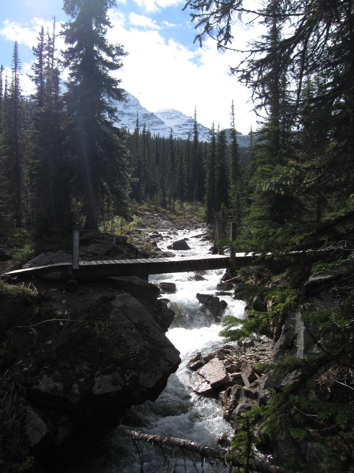
 Le paysage entre le camping et le glacier Athabasca est magnifique. On longe une rivière majestueuse qui parfois semble infiniment large et calme et parfois se résume à un torrent pris entre deux falaises.

 La montée vers le glacier est essoufflante. On sait plus comment respirer. Ça va être le gros party en descendant.
 Au glacier, on s'engouffre des mets chinois et des mauvaises poutines avant de marcher le long de l'amas de glace. Amélie est dégoûtée par ce qu'elle voit. Avant, on pouvait marcher directement sur le glacier mais maintenant, il y a des dizaines d'avertissements qui nous interdisent d'y aller. Faut quand même avouer que c'est pas mal beau.


 Sur le chemin du retour, on croise deux Australiens qui font eux aussi la route des glaciers en vélo. Ils ont l'air d'avoir froid dans leurs habits de vélo hi-tech.On redescend les montagnes à des vitesses vertigineuses. 40 km/h de moyenne pendant 19 min. Pas trop mal. Ça devient une tradition, on rentre au camping au soleil couchant. Le ciel est magnifique là-haut. Distance: 95 km


lundi 13 septembre 2010
13/09/10 Lake Louise to Rempart Creek (Icefield)
Yesterday we were so cold and so wet that we were ready to run away from the Rockies and seek for the warmer spots of the Okanagan valley. Today the weather is not so bad despite of the ugly weather forecast displayed at the tourist information center. We decide to buy some food at the really expensive grocery store of Lake Louise and then, bike into the Icefield Parkway. We stop for lunch at the Mosquito Creek camping. Up to now, the road is not so bad. we are definitely going uphill but it is not too steep. We had and accounter earlier with a black bear. When I saw him, he was 10 m from me eating berries just beside the ditch behind a bush. I stopped and started talking with him. He definitely didn't care of me, too busy eating his berries. We cross the road to put some distance between us. Eventually, few cars stopped and the bear runned in the wood.

 From Bow Summit, we start going down fast. The landscape is amazing. I particularly enjoy the sunset in the Saskatchewan crossing valley.


We finally reach the Rempart Creek camping almost in the darkness. It is very cold outside. By chance, there is a shelter with two nice wood stoves. I make a big fire to heat the place a little bit while Amelie is making the dinner. Although the camping is full of RVs, we see nobody. Everyone is in his heated camping car, watching satellite tv or doing who knows what else. Sometimes, it makes no sense to me, all those travelers, surrounding by other travelers from everywhere around the world but still isolated in their own little truck. Distance: 92 km
dimanche 12 septembre 2010
12/09/10 Bow Valley Parkway
Une journée bien moche, minée par la pluie et le froid. Lorsqu'on se lève, l'air est glacial et il pleut de temps en temps. On roule jusqu'à Johnston Canyon. Comme des cloches, on décide de visiter avec nos souliers à clip dans les pieds. Pas super marcher 6 miles sur des roches avec des bouts de métal sous les pieds. En plus, depuis Lac Bourgeau, Amélie a mal à un genou lorsqu'elle descent. Elle a développé une façon de déambuler qui lui fait moins mal mais ça lui donne la démarche d'une personne qui prend trop de morphine (un peu comme le gars d'Eau-Claire au Wisconsin).


De retour en bas, il pleut et on n'a pas d'énergie. On commence également à être limiter en terme de bouffe. On se rend de peine et de misère à Lake Louise sous une pluie torrencielle. En route, on a vu un grizzly immense qui marchait dans une prairie en bordure de la route. Je sais pas si je préfère voir un grizzly ou bien pas en voir du tout. On échoue au resto de l'auberge jeunesse. Le repas chaud et l'environnement sec nous fait le plus grand bien. On prend notre courage à deux mains et on s'en va camper sous la pluie froide au camping électrifié du village. Je rêve d'une plage dans le sud ce soir, garantie! Distance: 55 km
samedi 11 septembre 2010
11/09/10 Lake Moraine
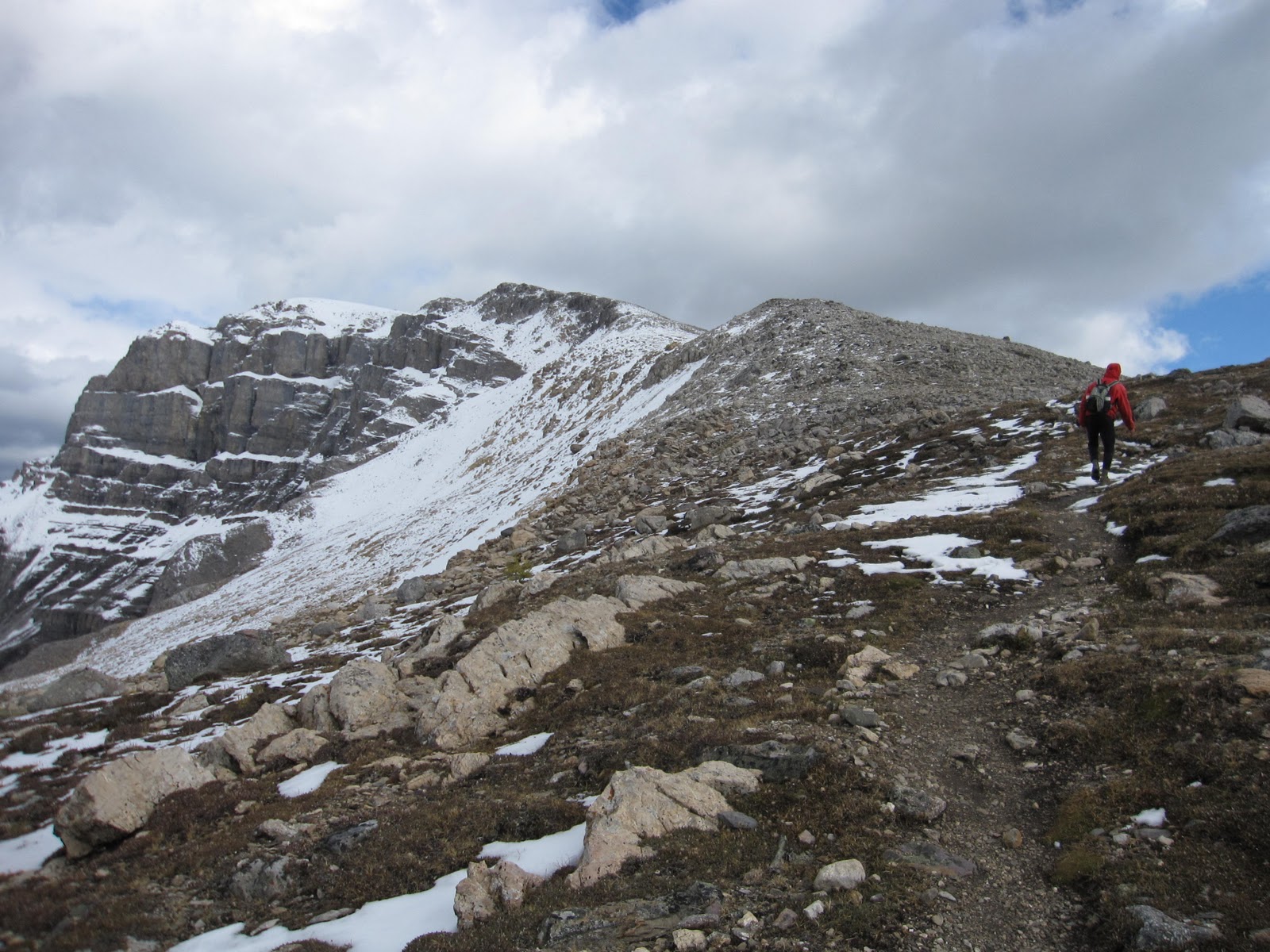
Justin est un gars de parole et comme convenu, il vient nous prendre au parking du Lac Bourgeau vers 10h. On roule jusqu'au Lac Moraine pour faire le Col Sentinel. Dans la montagne, les couleurs sont magnifiques. Ici c'est plus touristique. Il y a du monde partout. On marche avec un gars de Calgary qui essaye de nous expliquer que nous les québécois ont devrait faire nos devoirs au lieu d'emmerder le reste du Canada. On marche plus vite. Il va bien finir par être assez essoufflé pour se taire.
En haut, le paysage est magnifique. On est dans une espèce de cuvette enneigée. Pas mal comme endroit compte tenu des seulement 500 m d'élévation qu'il y a pour s'y rendre.


Le temps change rapidement et on redescend sous une tempête de neige bien assumée. Justin meurt de froid. En bas on fait une pause sur la plage du lac Moraine.


Plus tard, Justin nous dépose au parking du Lac Bourgeau. Nos vélos n'ont pas bougés. On décide de reprendre le Parkway et de se diriger tranquillement vers Lake Louise. On campe à proximité de la halte Sawback. Merci Justin pour cette agréable journée. Décidément c'est toujours un plaisir de te revoir. À la prochaine.
vendredi 10 septembre 2010
10/09/10 Bourgeau Lake
Ce matin je me lève reposé et prêt pour une autre randonnée. Amélie, elle, n'a pas dormi de la nuit. Trop effrayée par les ours, elle a passée la nuit les yeux ouverts à écouter les bruits dans la forêt.
Parfois, on fait des plans pas possible mais ça fonctionne. Demain, on est supposé faire une randonnée avec Justin mais il faut d'abord l'appeler aujourd'hui afin de lui donner rendez-vous. On roule donc 6 km jusqu'à Banff pour faire une petite épicerie et appeler Justin puis on roule dans la direction opposée pendant 20 km pour se rendre au parking du Lac Bourgeau, une randonnée de huit heures qu'on veut faire aujourd'hui. 26 km de vélo et 20 km de marche en montagne c'est quand même pas mal. Le reste s'explique mieux en image...


Lac Bourgeau: 20 km, 1025 m d'élévation
En haut du col Harvey, on pousse plus loin que la fin de la trail sans s'en rendre compte. On marche dans la neige et notre cerveau manque d'air. On a dû se rendre au moins 75 m de plus haut que prévu. Quel paysage!
De retour en bas, on se campe dans le terre-plein boisé qui sépare les deux voies de l'autoroute. Ici, l'autoroute est clôturé alors il n'y a pas de chance de voir des animaux. Amélie pourra dormir sur ses deux oreilles.
jeudi 9 septembre 2010
09/09/10 Cory Pass
After a minimalist breakfeast (one croissant and one toast, but we don't really care since it was so cheap), we jump on our bike and roll down to the Cory Pass parking. We hide the bikes in the woods, hang the food between two trees and have a second breakfeast before walking the trail.
 The trail starts hard. It goes really steep along a ridge. we are surrounded by cliffs so abrupt that Amelie is feeling dizzy.The Pass itself is a cold and stony passage. It remembers us the desolation landscape of the Mordor in the movie "The Lord of the Ring". On the other side of the pass, we can see the massive Brewster mountains. On the way back in the valley, we can see numerous signs of bear activities: eated berries, footprint, scratched bark and obviously huge bear poo. Yes, we are in bear contry! Amelie is scared so she doesn't stop singing and talking loud to chase the animals.

 When we arrive at the parking, it is pretty late and we decide to camp in the woods just beside the parking. It will be our first real test sleeping with the bears and the grizzlies. At dark, we pitch the tent. Suddently, we heard a loud noice and see spotlights. Shit! Hope this is not the ranger. We are not supposed to camp here. We wait in silence and immobility for a couple of minutes and then decide to check what is going on. Fiou! This is only a Westfalia doing the same has we do, camping in a restricted parking area.


Cory Pass: 13 km, elevation gain 915 m
Inscription à :
Articles (Atom)


